


OnX Hunt is a hunting app showing us the boundaries of every property, which is restricted on a map. We can use the application to locate the area around us, permitting us to geolocate.
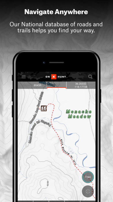
OnX Hunt is your cellphone’s most dependable and precise GPS satellite and topo maps application. Use it as a fully functioning GPS navigation app to see landowner names and property lines on your custom maps, hunting units, mountain roads, and trails. US topographic maps and other content are easily accessible.
Free Subscription
When you install the onX Hunt App, you will start a free seven-day Premium State Membership trial. The App and many features are free, but you will be charged for a Premium State Membership if you do not cancel before the end of the free trial period.
Paid Subscription
OnX Hunt is the GPS app that allows you to drive to a location by dropping a pin on a computer or smartphone and then using Google Maps, but this technology isn’t free. All 50 states are accessible in one of two ways—as part of an elite membership for $99.99 a year or as part of a $14.99 monthly subscription. Users may also purchase single-state map packages for $29.99 a year.
Maps or Layers
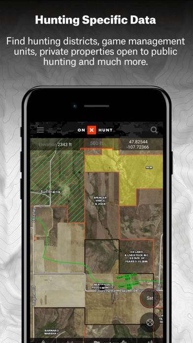
OnX offers three primary layers—satellite imagery, topographic, and a hybrid combining satellite imagery with topo lines—to include specific information in your maps. OnX’s powerful layers are an essential part of my strategy. Identifying what terrain is open to hunting when you are scouting or hunting unfamiliar areas is critical.
These layers give you a notion of what public land is accessible in a state. National forests and Bureau of Land Management property are prevalent in the West. Hunting areas are often limited to state lands east of the Mississippi River. OnX has generated maps of all types of public land and hunting areas.
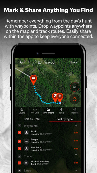
Waypoints and Estimation
OnX includes tools other than layers to assist hunters in the field. Using the line distance feature, you can calculate the distance between routes, see how far you are from roads and trails or estimate how far you are from the next ridgeline. Using OnX, you can create and label waypoints with over 70 different trail camera graphics, from trail cameras to treestands, and you can use them to navigate. If you remember, you will not become lost and know exactly where you were when scouting.
Tracking
The breadcrumb or dotted-line-style “track” provided by OnX is what you would use when you want to map your trails. The tracker is critical to locating lost animals when you do not have a good blood trail. It allows me to grid-search an area and see what ground I have yet to cover.
Offline Service
Even if you’re in the middle of nowhere with no data, you can still access the areas and layers you want for offline usage. You may choose between five miles wide at high resolution, ten miles wide at medium resolution, or 150 miles wide at low resolution.
Saving medium-resolution maps is my preferred method because they provide more than enough detail for me. Another benefit of using the app over a standard GPS is that you can use your bigger, brighter, and sharper smartphone screen to see more details and navigate more easily.
Desktop Version
With an OnX account, you can access your maps through a web browser just as you would on your smartphone. You may use the app on your laptop or computer to perform the same tasks, and any updates you make on your smartphone will be transferred to the app.
This allows you to see much more—your desktop monitor or laptop display rather than a smartphone screen—while planning trips. In addition, you can send track, line, and waypoint information via text message to your hunting companions.
Conclusion
OnX Hunt is the ultimate hunting app. If you hunt in any way, from the most basic to the most advanced, you will find tons of helpful information here. Not only does it provide you with access to a wide range of maps and data, but it also allows you to interact with other hunters and share your hunting experiences with others.
With an OnX account, you can save your favorite maps, tracks, and waypoints for offline use, and you can share these among your hunting group or upload them to your social media profiles. The app is perfect for anyone who loves to hunt and loves to be outdoors.
You might also like: Deer Hunter Classic
Related Apps

Phone Tracker for iPhones (Track people with GPS)

HERE WeGo – City navigation

GoSkyWatch Planetarium – Astronomy Night Sky Guide

Speedometer Speed Box App

Land Nav Assistant